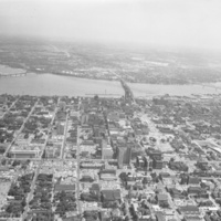
Aerial View of Downtown Louisville, Louisville, Kentucky
Dublin Core
Title
Aerial View of Downtown Louisville, Louisville, Kentucky
Subject
Aerial Photographs; Cities & towns; Bridges
Description
An aerial photograph of downtown Louisville, the Ohio River, and Southern Indiana with the George Rogers Clark Memorial Bridge, also known as the Second Street Bridge, in the center of the river. Title supplied by cataloger.
Source
8 x 10 in. b&w film negative. Item no. ULPA R_50546_n in the Royal Photo Company Collection, University of Louisville Photographic Archives.
Contributor
Royal Photo Company
Format
image/jpeg
Still Image Item Type Metadata
Original Format
photo
Files
Collection
Citation
“Aerial View of Downtown Louisville, Louisville, Kentucky,” History of the Parkland Neighborhood, accessed April 20, 2024, https://exhibit.parklandhistory.org/cms/items/show/66.

